SAND MINING AT AREA 1
AND DUMPING AT (i) JURONG ISLAND LNG PROJECT
AND (ii)PASIR PANJANG TERMINAL PROJECT WORKING AREAS
from PORT MARINE NOTICE, NO. 140 OF 2008 dated 31 Jul 2008
This is a revision of Port Marine Notice No 106 of 2008.
The working area at PPT has been revised and working period extended.
With effect from 1 Aug 08 to 31 Jan 09
DREDGING AREA: Area 1, Eastern part of Singapore (wildfilms note: no map included of this area in the Port Notice)
DUMPING AREA (Jurong Island Project – Working Area A & B) DUMPING AREA (Pasir Panjang Terminal Project – Working Area 6)
 24 hours daily including Sundays and Public Holidays.
The reclamation works will involve dredging by Trailer-Suction-Hopper-Dredger (TSHD) at Area 1.
Area 1 extends from the Singapore Port Limit into the westbound lane of the Traffic Separation Scheme (TSS) within the Singapore Strait.
All dredged materials will be dumped at Jurong Island project (see Working Area A and B of plan Attachment-1) and Jurong Island LNG project (see Working Area C of plan Attachment-1) and Pasir Panjang Terminal project (See Working Area 6 of plan Attachment-2)
Further enquiries relating to the project can be directed to the following Project Co-ordinators:
Jurong Island project and Jurong Island LNG project: Mr. A. Muhaimin at Tel No: 98178572, email: muhaimin@pkdbh.com.sg; and
Pasir Panjang Terminal project: Mr. Y. Abe at Tel No: 9664 8810, email: y.abe@mypenta.net .
Jul 31, 2008
Dredging and dumping at Jurong and at Labrador

Jul 25, 2008
Massive dredging off Cyrene Reef begins
DREDGING WORKS FROM JURONG ISLAND TO PULAU ULAR
from PORT MARINE NOTICE NO. 139 of 2008 dated 23 Jul 2008
With effect from 30 Jul 08 to 30 Nov 08, at Selat Pandan, Sinki Fairway and West Keppel Fairway, 24 hours daily, including Sundays and Public Holidays. Dredging works will be carried out by the grab dredger “Pandora” within the sectors as indicated in the chartlet. The grab dredger will be held in position by a 4-point anchor mooring system within the working area. The anchors will be marked by marker buoys. The safety working zone is a circular area of 200-metre radius centred at the dredger. A safety boat will be deployed in the immediate vicinity of the working area to warn other craft of the project work.
Further enquiries relating to the project can be directed to Mr P Bogers, the project manager, at Tel No: 9139 6094 or email bog@vanoord.com wildfilms note: besides this dredging work, the massive reclamation project at Pasir Panjang Port is also near Cyrene Reef.

Marine construction off Labrador continues
MARINE SOIL INVESTIGATION AT PASIR PANJANG TERMINAL PHASES 3 AND 4
from PORT MARINE NOTICE NO. 138 of 2008 dated 23 Jul 2008
With effect from 26 Jul 08 to 19 Sep 08 at West Keppel Fairway, 24 hours daily, including Sundays and Public Holidays. Soil investigation works will be carried out by means of marine boring using jack-up barges. The tug boat will be used for the shifting of the jack-up barges. There are no anchors required for the jack-up barges. The safety zone is a circular area of
30-metre radius centred at the locations of the jack-up barges. A safety boat will be deployed to warn other vessels to keep clear of the barges for the whole duration of the works.
Further enquiries relating to the project can be directed to Mr Y Abe, the project co-ordinator, at Tel: 9664 8810, email: y.abe@mypenta.net.
wildfilms note: this is a continuation of the massive reclamation project to develop Pasir Panjang port.
Jul 17, 2008
Massive reclamation at Labrador continues
RECLAMATION AT PASIR PANJANG TERMINAL AND PASIR PANJANG WHARVES
from PORT MARINE NOTICE NO. 134 of 2008 dated 16 Jul 2008
This is a revision of Port Marine Notice No.117 of 2008. The working area has been revised and working period extended.
With effect from 19 Jul 08 to 18 Jan 09, Location : In the vicinity of Pasir Panjang Terminal and Pasir Panjang Wharves, within a working area bounded by the following co-ordinates (see attached plan) 24 hours daily including Sundays and Public Holidays. Works will include reclamation, dredging, soil investigation, caisson construction, demolition of PW 1 and PW 2 and removal of submarine cables and pipelines. Soil investigation works will be carried out by jack-up barges attended to by tug boats. Safety boats will be deployed in the vicinity of the work area to warn other craft and vessels of the project works.
Further general enquiries can be directed to Mr Y Abe, the project coordinator, at Tel: 9664 8810, email: y.abe@mypenta.net.
wildfilms note: This is the work site in relation to Cyrene Reef (coloured yellow). See also post on recent visit to Labrador.
Jul 10, 2008
How are corals relocated from Sentosa IR worksite doing?
On the Sentosa Resorts World website
In keeping with our blue footprint, in July 2007, RWS engaged marine biologists from appointed consultancy firm, DHI Water & Environment Singapore, to relocate corals and other marine life around the Sentosa northern coastline affected by reclamation works to the Southern Islands.See the video clip on the Sentosa Resorts World website of the coral relocation and status of relocated corals one year after, link on this page.
After a year in their new homes, we are proud to share that the relocated corals are thriving beautifully.
Here's some screen shots from the clip, ostensibly the 'before' situation.

 Some information provided in the clip:
- "About 100 corals were moved".
- "Reported coral density along Sentosa's surrounding waters was sparse with less than 10% of the area covered with reefs".
- Also 'rescued': frogfish, nudibranchs, one octopus, more than a dozen seahorses
- "In Apr 2008 a marine survey shows that more than three quarters of transplanted corals are doing well."
- "The seahorses had settled into their new home."
- The coral relocation involved careful removal, transportation and relocation of more than 600 corals of 33 genera, measuring 20cm to 100cm across.
- Marine creatures such as nudibranches, seahorses and frogfishes were relocated as and when they were encountered during the relocation.
from Coral relocation at Sentosa Integrated Resort reclamation site DHI website 23 Jul 08 - At least 200 corals - of some 20 varieties - measuring 30 to 50cm across will be moved in cages over three weeks by marine biologists from consultancy firm DHI Water & Environment.
- Despite trying to "save as much as possible," DHI estimates some two-thirds of the corals will be sacrificed.
from Sentosa corals to move to Southern Islands by Shobana Kesava, Straits Times 7 Jul 07
- The survival rate of relocated corals in Singapore is about 80 to 90 per cent.
from The big reef move by Daphne Chuah, Today Online 7 Jul 07
Related post: "Possibilities of a truly integrated development?"
Jul 3, 2008
Oil rig work site opposite Semakau's natural shores
OIL RIG “ESSAR WILDCAT” AT THE RAFFLES RESERVED ANCHORAGE
from PORT MARINE NOTICE NO. 129 of 2008 dated 2 Jul 2008
With effect from 6 Jul 08 to 21 Aug 08 at West Jurong Anchorage, 24 hours daily including Sundays and Public Holidays Off-loading and loading of drilling equipment and maintenance works will be carried out onboard the rig. The work barges will be used for the transportation of the equipment to the shore facility.
Safety boats will be in attendance during the entire stay of the rig at the anchorage.
Further general enquiries relating to the project can be directed to Mr Jimmy Nicol, the project manager, at Tel No: 91188208.
wildfilms note: This area is just opposite the natural shores of Pulau Semakau where public intertidal walks are conducted and where the coral nursery is located. In addition, there was an earlier notice of construction of a fish farm in this area.
Links to more
- Singapore's first coral nursery Tania Tan, Straits Times 16 Apr 08
The oil rig taken from Pulau Hantu.
 Taken on the way home with indications of the locations of Pulau Semakau, Raffles Lighthouse (RLH) and Pulau Senang. Raffles Lighthouse and the Live Firing Islands of Sudong, Pawai and Senang have some of the last untouched reefs in Singapore. While Pulau Semakau has good natural shores. Let's hope this massive activity does not impact these nearby reefs.
 A closer look at the oil rig.
 Here's a photo of the oil rig taken on Pulau Semakau on 3 Aug 08

The work period was extended to September in a follow up notice. More on the wild shores of singapore blog.
Jun 25, 2008
Singapore is getting greener; now for a bluer Singapore
extracts from Singapore is getting greener
by Arti Mulchand, Straits Times 25 Jun 08;
full article on wildsingapore news
The area of the island covered by greenery has gone up from 36 per cent in 1986 to 47 per cent last year, despite the country's population shooting up from 2.7 million to 4.6 million during this period.
One reason: 10 per cent of the land here is set aside for nature reserves and parks, allowing for biodiversity in habitats including lowland rainforests, freshwater swamp forests and coastal forests to be conserved, said NParks chief executive Ng Lang.Over the years, a network of park connectors, streetscape and waterfront greenery has also added to the shades of green.
This means Singapore's rich biodiversity has been able to flourish as well - the island is now home to over 2,900 species of plants, 360 species of birds and 270 species of butterflies, with more species of flora and fauna yet to be identified.
It means that despite rapid population growth, Singapore has been able to recover from the loss of species to an extent that there is a balance, Mr Ng added.
Singapore's greening even got the nod from Dr Ahmed Djoghlaf, executive secretary of the United Nations' Convention on Biological Diversity, who gave a presentation on cities and biodiversity at the World Cities Summit yesterday,
'Unsound urban management is not the unavoidable destiny of cities. Sound urbanisation and ecologically managed cities can exist. Singapore, the garden in the city, is indeed living testimony of this reality,' he said.
The country is also taking a step forward in the global protection of biodiversity.
Early next year, a panel of experts and policymakers will meet in Singapore to craft a 'Cities Biodiversity Index', so cities can better manage biodiversity and integrate it into urban planning.
The idea for it came from Minister for National Development Mah Bow Tan at the Bonn Diversity Summit in Germany last month, to assist cities in benchmarking their biodiversity conservation efforts.
Commenting on it, Mr Ng said: 'You can't manage what you can't measure. So it will create a more scientific approach to helping countries know where they stand relative to others.'
The index will be ready before the next UN biodiversity conference, to be held in Nagoya, Japan in 2010. Countries will then assess their progress in achieving previously set biodiversity targets.
Their progress is crucial, said Dr Djoghlaf, who added that the rapid urbanisation of the world has led to an unprecedented loss of biodiversity, and that as the population of city dwellers balloons, the level of urgency escalates.
'The battle to protect biodiversity - and life on earth - will be won or lost in cities,' he said.
But it is not just species in danger - the jobs of three million people are at risk, for example, if marine life is lost, he added.
'We need to re-engineer our approach to development...People must realise that the loss of biodiversity will also have an economic impact and threaten livelihoods. We are conserving the economy of tomorrow,' he said.
Related articles
Bringing wildlife back to the city: Singapore’s idea
Sheralyn Tay, Today Online 30 May 08


Unfortunately for our shores, reclamation and coastal development has not had an equally happy result. Here are maps taken from the book "Singapore Waters—Unveiling Our Seas" by Nature Society (Singapore).
This was the coastline in 1950.
 And the coastline in 2002.
 Hopefully if the same attention to terrestrial biodiversity can be focused on our marine heritage, we can reduce the losses and perhaps even encourage a recovery in some of our coastal habitats.
Jun 20, 2008
Massive reclamation at Tuas and Jurong, more works off Labrador
RECLAMATION WORK AT TUAS VIEW EXTENSION
from PORT MARINE NOTICE NO. 121 OF 2008 dated 19 June 2008
This is a revision of Port Marine Notice No. 3 of 2008. The working period has been extended.
With effect from 7 July 08 to 6 January 09 at the Western part of Singapore. 24 hours daily including Sundays and Public Holidays.
The reclamation works involve shore protection and other ancillary works by the crane barges. The grab dredgers will be carrying out dredging, and the trailer-hopper-suction dredgers and hopper barges will be deployed to deposit reclamation materials. The crane barges and grab dredgers will be held in position by 4-point anchor mooring. Soil investigation will be carried out by the jack-up barges periodically. Further general enquiries relating to the project can be directed to Mr T Watanabe, the construction manager, at Tel No: 9668 1523, email:t.watanabe@mypenta.net
RECLAMATION OF JURONG ISLAND PHASE 4
from PORT MARINE NOTICE NO. 120 of 2008 dated 19 June 2008
This is a revision of Port Marine Notice No. 200 of 2007. The working period has been extended.
With effect from 3 July 08 to 02 January 09 at the Western part of Singapore. 24 hours daily including Sundays and Public Holidays.
The reclamation works will involve cutter suction (CS) dredgers, railer-suctionhopper (TSH) dredgers and hopper barges. Shore protection works will be carried out by crane barges and the dredging of sand-key trench by grab dredger.
Marine soil investigation works will be carried out by jack-up barge within Working Area “C”.
Further enquiries relating to the project can be directed to Mr T. Watanabe, the construction manager at Tel No: 9668 1523, email: t.watanabe@mypenta.net
MARINE SOIL INVESTIGATION AT PASIR PANJANG TERMINAL PHASES 3 AND 4
PORT MARINE NOTICE NO. 119 of 2008 dated 19 June 2008
This is a revision of Port Marine Notice No. 91 of 2008. The working period has been extended.
With effect from 20 June 08 to 19 July 08, at West Keppel Fairway. Soil investigation works will be carried out by means of marine boring using a jack-up barge. Tug boat will be used for shifting operation of the jack-up barge. There are no anchors required for the jack-up barge. However, a 30-metre radius centred at the location of the jack-up barge should work as a safety zone. A safety boat will be deployed to warn other vessels to keep clear of the barges for the whole duration of the works. Further enquiries relating to the project can be directed to Mr Y Abe, the project co-ordinator, at Tel: 9664 8810, email: y.abe@mypenta.net.
Jun 18, 2008
Reply to URA on the Draft Master Plan 2008
[update: URA replied to my feedback! More on the wild shores of singapore blog.]
The Master Plan feedback page only allows a reply of 2,000 characters.
So I've submitted the following summary with a link to the full reply which is posted on this blog.
Summary submitted
The Draft Master Plan 2008 does not seem to feature our natural reefs and shores. While some may say “no news is good news”, I am worried that our living shores may be overlooked when land use is being considered. I share here a little more about our living shores.
Aren’t all our shores reclaimed and dead?
Wild reefs bursting with life abound even in the middle of our port. Wild dolphins, sea turtles and otters are regularly spotted in our waters.
What’s so special about Singapore’s shores?
Uniquely Singapore! Where else in the world can a visitor quickly go from a high-level business meeting at a world class hotel to visit a living reef or mangrove? In under half an hour?
Can an ordinary person experience Singapore’s marine heritage?
Yes! “No need to swim, no need to dive!” Grandmas, small kids, everyone can visit our shores on guided walks.
Do Singaporeans care about our reefs and shores?
3,500 volunteers and 100,000 visitors a year say they do!
Why should Singapore value our reefs and marine habitats?
Beyond coral-hugger arguments, protecting our shores can make Singapore Real BIG Money. Read more!
Can Singapore afford NOT to learn more about our natural shores?
With current concerns about rising sea levels, can we ignore our shores?
What are some of the threats to Singapore’s reefs and shores?
We don’t have to bury our shores to kill them.
Come see our shores for yourself!
I’d gladly give a talk or organise a walk for you and your colleagues.
Here's the full reply which I'm emailing to their general enquiries email ura_email@ura.gov.sg
Full reply
The Draft Master Plan 2008 does not seem to feature our natural reefs and shores. While some may say “no news is good news”, I am worried that our living shores may be overlooked when land use is being considered.
I share here a little more about our living shores.
Aren’t all our shores reclaimed and dead?
Singapore has lots of living natural shores! Although many of our shores have been affected by development, reefs have crept back into artificial swimming lagoons and marine life reappeared on reclaimed land.
Spectacular wild reefs still exist in a few locations. For example, Cyrene Reefs has a rich variety of marine life, even though it is right in the middle of major shipping lanes and next to industrial installations at Pulau Bukom and Jurong Island, and opposite busy container terminals on the mainland.
The vast reefs of our Live Firing Islands have long been protected by virtue of land use and are considered among the healthiest of our reefs. They may even be in better condition than many other islands elsewhere in Peninsular Malaysia and nearby Indonesia which have not been protected from human exploitation.
Singapore also has vast seagrass meadows, on Chek Jawa in the north and Pulau Semakau and Cyrene Reefs in the south.
Wild dolphins are regularly sighted in our Southern Islands. Sea turtles are also still seen by divers at Hantu and baby sea turtles spotted hatching on the East Coast! Otters are regularly seen on many of our off shore islands and even mangroves on the mainland. Dugong feeding trails have recently been observed on Chek Jawa!
What’s so special about Singapore’s shores?
Singapore's shores are easy to get to! Uniquely Singapore! Where else in the world can a visitor quickly go from a high-level business meeting at a world class hotel to visit a living reef or mangrove? In under half an hour? The reefs of the Southern Islands are just 15 minutes away from the mainland by fast boat.
How do our reefs compare? The reefs in Singapore harbour close to 200 species of hard, which given the size of reefs and conditions present here, compare favourably with coral species richness in the more extensive reefs of the region. from the Coral Reefs of Singapore website, Reef Ecology Study Team, NUS
Can an ordinary person experience Singapore’s marine heritage?
“No need to swim, no need to dive!” Many volunteer groups provide guided walks on boardwalks and low tide walks for ordinary people. An ideal trip for the family, bring grandma and the little kids! (more details of these activities below).
In addition, there are regular dives at Pulau Hantu offered to the public by the volunteers of the Hantu Blog.
Do Singaporeans care about our reefs and shores?
Yes! About 3,500 volunteers every year work quietly to provide guided walks, guided dives, conduct regular monitoring of seagrasses and reefs, and to clean up and collect data on marine debris on our shores (breakdown of volunteers below).
An estimated 100,000 Singaporeans, residents and visitors visit our shores every year (details below). There is overwhelming interest in guided shore walks. All regular shore walks are quickly booked within days of being offered. The wait-list to view Chek Jawa remains long, even though it has been seven years since the shore walks were introduced, and long after skeptics said interest would wane.
Why should Singapore value our reefs and marine habitats?
Coral-huggers would of course say our shores are a priceless part of our natural and cultural history, as well as an outdoor classroom where children learn naturally, and a place where families can bond naturally.
If asked to put a price to this value, a coral-hugger might point out the ecosystem services provided by the reefs, the possibility of bio-products to be derived from reefs or argue that our living reefs will be valued by global clients of high net worth.
But can our shores make Singapore some real Real BIG Money?
Elsewhere in the world, reefs provide critical income through tourism, marine products or provide vital ecosystems services such as protection from extreme weather.
Singapore’s shores don’t seem to perform these roles. Are they thus useless and can be put to better use as reclaimed land?
Singapore faces severe limitations in land, water and other resource constraints. We have been forced to overcome them in a sustainable manner. Many other countries will soon face the same constraints, on a much larger scale.
Our living reefs and shores are testament to Singapore’s sustainable approach to development, undertaken long before it became fashionable.
For example, Semakau Landfill was developed and operated such that half of the original Pulau Semakau remains relatively undisturbed. So much so that nature walks are currently conducted of Pulau Semakau’s wild mangroves, vast seagrass meadows and amazing coral reefs!
Every development that impacts our shores should be seen as an opportunity to prove that we can develop and operate first-world facilities without wiping out natural habitats. This approach can be scaled up to meet the needs of other countries whose natural shores DO provide real income and high value ecosystems services.
A headline of the future?
“Singapore wins multi-billion dollar project to build eco-port
Singapore beat other major contenders to build a port next to pristine marine habitats important to the host country for tourism and fisheries.
The clincher: Singapore’s Cyrene Reef, a rich patch reef in the middle of the port area. This proves that Singapore has the know-how to build and manage world-class facilities in a sustainable manner.”
Can Singapore afford NOT to learn more about our natural shores?
With current concerns about rising sea levels, there is much to gain in learning everything we can about our marine habitats. Coral reefs are naturally growing ‘sea walls’. Similarly with mangroves. Do we know enough about the role of natural coastal ecosystems in flood control? Can we afford not to find out?
What are some of the threats to Singapore’s reefs and shores?
Coastal development has destroyed shores
We have already lost much of our natural reefs to reclamation. How much have we lost? "There were once over 60 offshore islands and patch reefs around Singapore. However, since the mid 1970s, most of the southern islands were reclaimed. Since 1986, most coral reefs in Singapore have lost up to 65% of their live coral cover". from Coral Reefs of Singapore, Reef Ecology Study Team, NUS
Coastal activities kill our shores
We don’t have to bury our shores to kill them.
Murky, sediment-laden water is bad for marine life. Why? Corals and many important marine organisms need sunlight for good health and growth. Sediments smother marine life, making it hard for them to feed and reproduce. Just like the haze, murky waters make marine life ill.
Where does the murky water come from? High levels of coastal activity (shipping, dredging, dumping of spoils at sea) and other careless coastal development results in plumes of sediments that can affect a vast area. In the same way that burning in faraway lands can result in haze in Singapore.
How murky is our waters today? "The high turbidity of our waters restrict light penetration and reef life ends at a depth of only 12m. Sedimentation rates ranged from 3-6mg/cm2/day in 1979. In 1994, these increased to 5-45mg/cm2/day (the higher value obtained from localised areas close to reclamation projects). This reduced visibility from 10m in the 1960s to 2m or less today. As a consequence, the reef is very compact, as opposed to reefs in clear waters, which can be found at depths of 20m and more." from Coral Reefs of Singapore, Reef Ecology Study Team, NUS
Come and see our living shores for yourself!
I gladly give a fuller introduction of the shores to you and your colleagues. I could give a talk, and/or arrange a walk on any of our marvelous shores.
I look forward to sharing more of our living shores with you!
Ria Tan
More background on visitorship to and volunteers for our shores
Visitorship to our shores
Chek Jawa: about 20,000 people annually
from "Chek Jawa guided tours no longer free", Shobana Kesava, Straits Times 12 Dec 07
Sungei Buloh: about 80,000 people annually
from National Library Board infopedia by Pwee, Timothy and Pak, Peter Yew Guan
Kusu Island: about 300 people annually
Pulau Semakau: about 300 people annually
Pulau Hantu dives: about 150 people annually
Volunteers on our shores and their activities
The internet resources of these groups also provide outreach on the shores. Hit rates (where available) as at Jun 08 are indicated.
International Coastal Cleanup Singapore about 3,000 volunteers for the 2007 event
Conducts data collection of marine debris on our shores.
http://coastalcleanup.nus.edu.sg/ (12,000 hits)
http://coastalcleanup.wordpress.com/ (6,000 hits)
Chek Jawa (NParks) about 200 volunteers
Conducts guided walks on the shores of Chek Jawa.
http://www.nparks.gov.sg
Blue Water Volunteers about 100 volunteers
Conducts guided walks at Kusu Island, underwater reef surveys and guided dives at Singapore’s reefs, as well as outreach through talks and exhibitions.
http://www.bluewatervolunteers.org
TeamSeagrass (with NParks) about 100 volunteers
Monitors the seagrass meadows at 6 locations as well as outreach through talks and exhibitions.
http://teamseagrass.blogspot.com (7,000 hits)
Naked Hermit Crabs about 40 volunteers
Conducts guided walks at the Chek Jawa boardwalk every month, and family walks at Sentosa’s natural shores during the school holidays as well as outreach through talks and exhibitions.
http://nakedhermitcrabs.blogspot.com (12,000 hits)
Sungei Buloh Wetland Reserve (NParks) about 40 volunteers
Conducts guided walks at the Reserve
http://www.sbwr.org
Hantu Bloggers about 30 volunteers
Conducts guided dives at Pulau Hantu as well as outreach through talks and exhibitions.
http://www.pulauhantu.org (130,000 hits)
Raffles Museum of Biodiversity Research (NUS) about 30 volunteers
Conducts guided walks at Pulau Semakau and workshops for schools on our shores.
http://rmbr.nus.edu.sg/
International Year of the Reef 2008
Representatives from about 30 groups have come together to organise activities for this international event.
http://iyor08singapore.blogspot.com/ (12,000 hits)
In addition, personal blogs about our shores posted by these volunteers and other nature lovers are an additional source of immense outreach. Here's the latest posts about our wild shores.
Jun 14, 2008
Reclamation starts at Sentosa, massive works continue near Labrador
RECLAMATION WORKS AT CRUISE BAY
from PORT MARINE NOTICE NO. 114 of 2008 dated 12 June 2008
With effect from 18 June 08 to 17 Nov 08, at Sentosa. Working Area “A”
The works include construction of a sea wall, piling, dredging and land reclamation within the working area. Sea wall piling, drilling and socket work will be carried out together with casting of concrete capping beam and pre-cast fasica panel installation along the sea wall. Backfilling works behind the wall will run concurrently with the seawall construction. Silt curtain will be deployed to prevent siltation. Further enquires relating to the project can be directed to Mr Chris
Kelly, the project manager, at Tel: 9118 2802, email: chris_kelly@macdow.com.au .
Working Area “B”
Area will be used as a temporary staging for the importing of aggregate and materials used for the concrete batching plant and removal of excavated fill from the basement works. A safety boat will be deployed to advise all craft to keep clear of the working area.
Further enquires relating to the project can be directed to Mr Kwan Soon Boon, the project manager, at Tel: 9150 6390, email:
sbkwan@ktcce.com.sg wildfilms note: This is what the area looked like when we visited Sentosa last month. We also noted coral bleaching during that visit on the natural shores of Sentosa around the corner from this work site.
RECLAMATION AT PASIR PANJANG TERMINAL AND PASIR PANJANG WHARVES
from PORT MARINE NOTICE NO. 117 of 2008 dated 13 June 2008
This is a revision of Port Marine Notice No. 104 of 2008. The working area has been revised and
working period extended.
With effect from 20 June 08 to 19 Dec 08, in the vicinity of Pasir Panjang Terminal and Pasir Panjang Wharves, 24 hours daily including Sundays and Public Holidays.
Works will include reclamation, dredging, soil investigation, caisson construction, demolition of PW 1 and PW 2 and removal of submarine cables and pipelines.
Soil investigation works will be carried out by jack-up barges attended to by tug boats. Safety boats will be deployed in the vicinity of the work area to warn other craft and vessels of the project works. Further general enquiries can be directed to Mr Y Abe, the project
coordinator, at Tel: 9664 8810, email: y.abe@mypenta.net.
A) ROCK-FILLING OPERATIONS IN WEST KEPPEL FAIRWAY – SSD6
B) TEMPORARY HOLDING AREA IN WORKING AREA “A” (OFF LABRADOR PARK)
from PORT MARINE NOTICE No. 115 of 2008 dated 13 June 2008
The existing Port Marine Notice No. 108 of 2008 is superseded by this Port Marine Notice.
With effect from 21 June 2008 to 10 August 2008, at West Keppel Fairway and approaches to Cruise Bay, within working areas bounded by the following co-ordinates
Rock-filling works will be carried out 24 hours daily, including Sundays and public holidays, within the shaded areas of SSD-6 (bounded by Point D, A, B and E).
Working area “A”, within the shaded area of “A” (bounded by Point RF1 to Point RF8) in the vicinity of Labrador Park, has been identified as the temporary holding area for the rock-filling works.
Rock-filling Works
Rock-filling work will be carried out by tremie barge at Working Area “SSD-6”. There will be only one (1) barge carrying out rock-filling works in the working Area “SSD-6”. Tremie barge will be held in position by 4-point anchor mooring system. A safety working zone of 200-metre radius is centred at the tremie barge. Safety boat will be stationed in the immediate vicinity to warn other craft of the project work. Emergency safety tug will be stationed at all times to assist during emergency. The tremie barge will be required to shift to Working area ‘A’ where
necessary. Further enquiries relating to this operation can be directed to Mr Emir Himzari, the project co-ordinator at Tel. 9125 5998, e-mail: emir@eastmarine.com.sg.
May 31, 2008
Draft Master Plan 2008 and our shores: why should I care?
Today I visited the Master Plan exhibition at URA, and spent a lot of time going through their website.
Why should I care about the Master Plan?
The Master Plan guides development in Singapore. It is important to understand the principles that guide master planners. And if there are gaps in understanding the situation on the ground, it is up to us to highlight these issues. Those of us who know and care, MUST speak up. To tell planners where there are good examples of our marine heritage. So that these are taken into account during the planning process.
So please do try to visit the exhibition (more details on the URA website), and give your feedback. I will be sending links to these posts as feedback to URA on the Master Plan. If you prefer, you can simply add your comments to this blog.
What is the Master Plan?
The Concept Plan
The Concept Plan is Singapore’s strategic land use and transportation plan to guide development in the next 40 to 50 years. The Concept Plan is reviewed every 10 years.
The Master Plan
The Master Plan is the statutory land use plan which guides Singapore's development in the medium term over the next 10 to 15 years. It is reviewed every five years and translates the broad long-term strategies of the Concept Plan into detailed plans to guide development. The Master Plan shows the permissible land use and density for every parcel of land in Singapore.
Concept Plan Review A mid-term review of the Concept Plan in 2006 concluded that there is sufficient land to cater to Singapore’s future needs while maintaining a good quality living environment. The broad strategies arising from the review are:
* Need to make better use of land: There is a need to make more creative use of land to meet future needs, such as using underground spaces and co-location of compatible uses.
* Decentralisation through new growth centres: New growth centres outside of the city are proposed at Jurong and Paya Lebar.
* Priority on public transport: Priority has to be given to the use of public transport to meet the increasing transportation needs.
* Enhancing Quality of Life & Sense of Identity: The quality of life can be enhanced by providing for a greater variety of leisure options. At the same time, there is also a need to selectively retain Singapore’s built and natural heritage to foster our sense of belonging.
How are our wild places seen in terms of urban planning? Our parks and nature places fulfil the 'Play' element of the 'Work, Live and Play' theme in urban planning.
 Nature is clearly a part of the leisure plan.
 Some of the designated activities include:
 As well as
 Other activities related to the marine environment include: marina and pleasure boating, sailing, kayaking/canoeing, water skiing/wakeboarding, fishing and scuba diving.
Other activities related to the outdoors include: dragonboat, water taxi, motorsports, golfing, horseriding, rollerblading and other sports
Non-outdoor activities considered include: shopping, lifestyle and dining, arts and culture and community.
Which are the areas designed with the sea star for "Marine Nature Spot"?
Chek Jawa at Pulau Ubin Labrador
 Pulau Semakau has a sea star. Pulau Hantu doesn't but it is the only location with a scuba diving icon.
 While there are a lot of different leisure icons for Sentosa, there are none for the Southern Islands nearby: Kusu, St. John's and the Sisters Islands.
 Sungei Buloh Wetland Reserve doesn't get a "sea star" but has all the other relevant icons.
 Changi doesn't get a "sea star"
 Neither does Pasir Ris.
 Do our shores exist?
On the big table top model of Singapore ... All our Southern Islands have dropped off the table.
 And there's only half of Pulau Ubin with Chek Jawa off the table.
In the panel devoted to Playing with Water ... Some of our Southern islands have also dropped off the map, including Pulau Hantu, the only location with the scuba icon, which is on the Water Activities Plan legend, but doesn't appear on the map.
 Is it a bad thing that urban planners know little about our shores?
While no news can be taken good news, it also does mean that plans will not take into account the presence of good reefs and our other shore habitats.
However, the planners do seem to have some awareness of the shores as a part of the lives of Singaporeans. In the panel featuring memories of physical places, there were lots of photos of people on the shores.
 Across time.
 Both natural and man-made shores.


 Trips to the Southern Islands.
 Even Chek Jawa!
 The life-vests suggest these are government visitors, and they are visiting before the boardwalk was built.
 Enthralled on Chek Jawa.
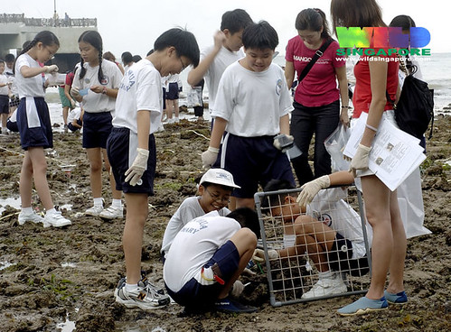 Living classroom at Labrador
 Delighted at Pulau Semakau.
 Exploring our City Reefs on Kusu Island. Just minutes from the city centre.
 Exploring Sentosa's surprising natural shores.
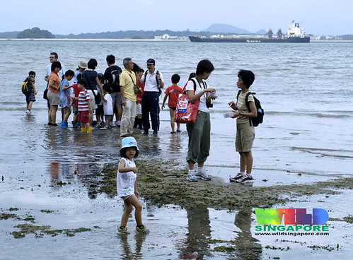 For all ages at Changi.
 Communing with wildlife on Chek Jawa.
Links to media articles on the Master Plan
- Transforming Singapore: Draft Master Plan 2008
Business Times 29 May 08 - Making of Singapore into a lively, liveable global city URA's Master Plan looks at softer features of urban life and new needs like population growth
Joyce Teo, Straits Times 24 May 08 - Singapore: Leisure Island
NOTHING to do on the weekends in Singapore? Not if its city planners can help it.
Jessica Lim, Straits Times 22 May 08;
To give your views on the redevelopment plans, visit the Draft Master Plan 2008 exhibition at The URA Centre, 45 Maxwell Road from now till June 20.
Opening hours are 9am to 7pm (Monday to Friday), and till 1pm on Saturday.
Those who object to the proposals should write in to the Permanent Secretary, Ministry of National Development, 5 Maxwell Road, Singapore 069110 - with supporting reasons - before June 20.


